
그랜드캐년보다 큰
Submarine Canyons(해저협곡)
노아홍수의 물이 물러나면서 깎았다
Michael Oard 글, 이종헌 역
출처: creation magazine Vol. 41(2019), No. 3 pp. 48-51
MANY HAVE stood at the rim of Grand Canyon awed by its great depth and enormous size. Surprisingly, our Earth has other even larger canyons, but they are unseen since they lie underwater (fig. 1). These are submarine canyons that run away from the coast, sometimes starting close to shore. Submarine canyons are incredible landforms that point to the catastrophic impact of Noah’s Flood.
많은 사람들이 그랜드캐년의 가장자리에 서서 그 거대한 깊이와 엄청난 규모에 경외심을 나타냈다. 놀랍게도, 우리 지구는 다른 더 큰 협곡을 가지고 있지만, 그것들은 수중에 있기 때문에 보이지 않는다(그림 1). 이것들은 해안에서, 때로는 해변 가까이에서 멀리 떨어져 나가는 해저 협곡들이다. 해저 협곡들은 노아의 대홍수의 격변적 영향을 가리키는 놀라운 지형이다.
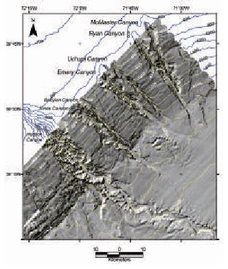
Fig. 1. Shaded relief map of seven submarine canyons off New York. Notice that six of them start on the edge of the continental shelf, but one, the large Hudson Canyon to the left, indents the continental shelf.
그림 1. 뉴욕의 근해의 7개 해저 협곡에 대한 음영 처리한 입체지도. 그 중 6 개는 대륙붕 가장자리에서 시작하지만, 왼쪽에 있는 커다란 허드슨 캐년 하나는 대륙붕을 움푹 들어가게 한다.
(그림 내용(역주): McMaster Canyon, Ryan Canyon, Uchupi Canyon, Emery Canyon, Babyton Canyon, Jones Canyon, Hudson Canyon)
Submarine canyons differ from deep-sea trenches, like the Mariana Trench, the deepest place in the oceans. Trenches generally run parallel to the shoreline in deep water. Submarine canyons, in contrast, start in shallow water, generally on the continental shelf, and run perpendicular to the continental margin down into deep water. They were eroded by the channelized flow of the receding floodwaters.(1)
해저 협곡은 해양의 가장 깊은 곳인 마리아나 해구(Mariana Trench)와 같은 심해의 해구와는 다르다. 해구는 일반적으로 심해에서 해안선과 평행하게 뻗어 있다. 대조적으로 해저 협곡은 일반적으로 대륙붕에 있는 얕은 물에서 시작하여 대륙 경계에 수직으로 심해로 흐른다. 그것들은 물러가는 대홍수 물의 수로화된 흐름에 의해 침식되었다.(1)
Submarine canyons differ from slope canyons, which are common.(2) Slope canyons have an average spacing of 33 km (20 miles)(3), and there are around 6,000 deeper than 100 m (330ft). Nearly all slope canyons sit along the steep continental slope and are relatively small. Slope canyons formed in the 4,500-year post-Flood era as loose sediment built up at the edge of the continental shelf and periodically avalanched down the slope.
해저 협곡은 흔히 있는 사면 협곡과는 다르다.(2) 사면 협곡의 평균 간격은 33km(20마일)이고, 깊이가 100m(330ft)보다 깊은 곳이 약 6,000개 있다. 거의 모든 경사 협곡은 가파른 대륙 사면을 따라 있으며 규모는 비교적 작다. 사면 협곡은 대홍수 후 4,500 년이 지났을 때 대륙붕 가장자리에 쌓인 느슨한 퇴적물이 주기적으로 사면 아래로 사태 나듯이 밀려 내려감으로써 생겼다.
By way of contrast, hundreds of larger submarine canyons are carved into the flat continental shelf. These are often but not always found seaward of rivers. And these are the canyons that were eroded late in Noah’s Flood as the floodwaters were receding in narrow channels.
그와는 대조적으로, 보다 큰 수백 개의 해저 협곡이 평평한 대륙붕 안에 깎여져 있다. 이들은 항상은 아니지만 종종 강물이 바다와 만나는 곳에서 발견된다. 그러므로 이들은 노아의 대홍수 후기에 홍수의 물이 좁은 수로에서 후퇴함에 따라 침식된 협곡이다.
Submarine canyons are enormous(해저 협곡은 거대하다)
Submarine canyons on the continental shelf begin at ocean depths ranging from about a metre to more than 300 m (1,000 ft). The average is 100 m (330 ft) near the edge of the continental shelf. The large Capbreton Canyon, perpendicular to the French coast but running roughly parallel to the northern coast of Spain, begins only 250 m (800 ft) from the shore at a water depth of only 30 m (100 ft)!(4) The Scripps Canyon off La Jolla, California, USA (which joins the La Jolla Canyon further off-shore) also starts close to the beach, so close in fact that if it continued to grow toward the shore, the Scripps Institute of Oceanography’s pier would collapse into the canyon.
대륙붕 상에 있는 해저 협곡은 약 1 미터에서 300m(1,000ft) 이상 되는 범위의 해양 깊이에서 시작된다. 대륙붕 가장자리 근처에서의 평균은 100m(330ft)이다. 커다란 Capbreton 협곡은 프랑스 해안과 수직을 이루지만 스페인 북부 해안과 거의 평행을 이루는데, 이는 해안에서 불과 250m(800ft) 떨어진 곳에서 수심이 30m(100ft) 밖에 안되는 곳에서 시작한다!(4) 미국 캘리포니아 라호야(La Jolla) 외곽의 Scripps 협곡도 해변 가까이에서 시작되는데, 사실상 너무 가까워서 해안쪽으로 발달되었다면 Scripps 해양학 연구소(Institute of Oceanography)의 부두가 협곡 안으로 붕괴될 정도이다.
The average length of a submarine canyon is over 50 km (30 miles). Sometimes the submarine canyon continues out over its deposits and forms a canyon on its submarine fan. If these fan valleys were included, submarine canyons would be much longer. For instance, Africa’s Congo Canyon would be 800 km (500 miles) long rather than 190 km (120 miles). The longest submarine canyon is the Bering Canyon (near the Aleutian Islands) with a total length of about 500km (310 miles, which is longer than Grand Canyon), including a fan valley 95 km (60 miles) long.(5)
해저 협곡의 평균 길이는 50km(30마일) 이상이다. 때로는 해저 협곡이 그 퇴적물을 지나서까지 계속 뻗어서 해저 선상지 상에 협곡을 형성한다. 이 선상지 계곡을 포함하면 해저 협곡은 훨씬 더 길어진다. 예를 들어 아프리카 콩고 협곡은 190km(120마일)가 아니라 800km(500마일)가 된다. 가장 긴 해저 협곡은 베링 협곡(Aleutian 제도 근처)으로써, 95km(60마일)의 선상지 계곡을 포함하여 전제 길이가 약 500km(310마일, 그랜드 캐년보다 길다)이다.
The depths of submarine canyons have attracted much attention. Some are deeper and wider than Grand Canyon. The wall height varies down a canyon, and the sides are rarely at the same depth. On average, the maximum height of the walls is about 900 m (3,000 ft)—greater than the average height of land canyons. The highest submarine canyon walls are in the Capbreton Canyon with a maximum height of 3,000 m (10,000 feet).(6)
훨씬 더 관심을 끄는 것은 해저 협곡의 깊이이다. 어떤 것은 그랜드 캐년보다 더 깊고 더 넓다. 벽의 높이는 협곡의 아래로 가면서 변화하며, 양 측면은 거의 깊이가 같지 않다. 평균적으로 벽의 최대 높이는 약 900m(3,000피트)로써 육지 협곡의 평균 높이보다 크다. 가장 높은 해저 협곡의 벽은 Capbreton 협곡에 있으며 최대 높이는 3,000m(10,000피트)이다.(6)
Monterey Canyon, California, is probably the most studied submarine canyon in the world (fig. 2). It starts in water 18 m (60 feet) deep near the pier at Moss Landing in Monterey Bay, and is 96 km (60 miles) long. Like so many other such canyons it continues onto its submarine fan fig. 3). Including its fan valley, the total length of the canyon is about 470 km (300 miles).(6) Its maximum wall height is 1,700 m (5,600 feet), and its maximum rim-to-rim width is 12 km (7.5 miles), similar to Grand Canyon.
캘리포니아의 Monterey 협곡은 아마도 세계에서 가장 많이 연구된 해저 협곡일 것이다(그림 2). 몬트레이 만(Bay)의 모스 랜딩(Moss Landing)에 있는 부두 근처에서 18m(60피트) 깊이의 물속에서 시작하여 96km(60마일) 길이이다. 다른 많은 그러한 협곡처럼 그것은 해저 선상지로 이어진다(그림 3). 선상지 계곡을 포함하여 그 협곡의 전체 길이는 약 470km(300마일)이다.(6) 최대 벽 높이는 1,700m(5,600피트)이고 이쪽 가장자리에서 저쪽 가장자리까지의 최대 폭은 12km(7.5마일)로써 그랜드 캐년과 비슷하다.
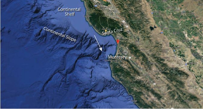
Fig. 2. Monterey Canyon (arrow), California.
그림 2. 캘리포니아의 Monterey 협곡(화살표)
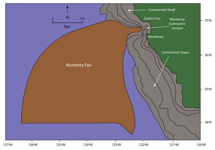
Fig. 3. The Monterey Submarine Fan offshore from Monterey Canyon (drawn by Melanie Richard).
그림 3. Monterey 협곡에서 앞바다로 향하는 Monterey 해저 선상지(Melanie Richard 그림).
Submarine canyons and coastal rivers(해저 협곡과 연안의 강)
Interestingly, many continental shelf submarine canyons are found seaward of rivers, and many features of submarine canyons are similar to river valleys. Submarine canyons have tributaries, meanders, meander loops, and horseshoe-shaped meander cutoffs.(7) So what caused these unique river-like features? Although the relationship between submarine canyons and rivers on land is significant, it does not support the idea that the canyons were formed directly by erosion by these rivers. There is no direct connection between the rivers and their nearby submarine canyons, either on the surface of the continental shelf or below the surface. The rivers end abruptly at the shoreline and the canyons start well offshore. And further, these features are usually found in deep water. In other words, the water level is too deep for the sea to have caused them. Whatever caused these features was the same process that carved the submarine canyons.
흥미롭게도 많은 대륙붕 해저 협곡은 강에서 바다쪽으로 발견되며 해저 협곡의 많은 특징은 강의 계곡과 유사하다. 해저 협곡에는 지류(tributaries), 곡류(meander), 곡류 만곡부(meander loop), 말굽 모양의 곡류 절단(cutoff) 등이 있다.(7) 그렇다면 무엇이 이들처럼 강과 같은 독특한 특징을 일으켰는가? 해저 협곡과 육지의 강 사이의 관계가 중요하지만, 협곡이 이들 강에 의해 직접 침식되어 형성되었다는 개념을 지지하지는 않는다. 대륙붕 표면이나 그 표면 아래에서 하천과 그에 인접해 있는 해저 협곡은 직접 연결되어 있지 않다. 강은 해안선에서 갑자기 끝나고 협곡은 앞바다에서 시작된다. 그리고 더 나아가, 이러한 특징들은 보통 심해에서 발견된다. 다시 말해서, 수위가 너무 깊어서 바다가 그들을 일으켰다고 보기가 힘들다. 이러한 특징을 유발한 원인은 무엇이든지간에 해저 협곡을 깎은 것과 동일한 과정이었다.
Long-age geologists have difficulties(오랜 연대 지질학자들은 곤란을 겪고 있다)
Uniformitarian geologists generally say that the large submarine canyons were formed by repeated sliding of sediment down the continental slope, until it eventually reached up onto the continental shelf. But why would the sliding focus on one location, over and over again, greatly deepening one canyon instead of creating multiple mini-canyons? Lastras and others write:
동일과정설 지질학자들은 일반적으로 커다란 해저 협곡은 퇴적물이 대륙 사면을 따라 반복적으로 미끄러져서 결국 그것이 대륙붕에 도달한 것이라고 말한다. 그러나 그 미끄러짐이 여러 개의 미니 협곡을 만드는 대신에 어떻게 해서 하나의 장소에 자꾸 자꾸 반복하여 집중해서 커다랗게 하나의 협곡을 깊게 만드는 것일까? 라스트라(Lastras)와 다른 사람들은 이렇게 말한다:
In spite of this large effort, a general world-wide accepted valid theoretical context of the location, evolution and activity of submarine canyons is not yet available.(8)
이러한 큰 노력에도 불구하고, 해저 협곡의 위치, 진화 및 활동에 대해 일반적으로 세계적으로 인정된 이론적인 맥락은 아직 유용하지 않다.(8)
Explained by Late Flood channelized erosion(대홍수 후기의 수로화된 침식으로 설명하기)
The problem for uniformitarians/long-agers is they lack a process that would focus eroded sediment from the continents at one location on the continental shelf. The process would need to continually feed sediment to slide down into the deep ocean and progressively carve and enlarge a submarine canyon.
동일과정론자/긴 연대주의자의 문제는 대륙붕의 한 위치에서 대륙으로부터 침식된 퇴적물에 집중하는 과정이 결여되어 있다는 것이다. 그 과정은 퇴적물을 지속적으로 공급하여 심해로 미끌어져 내려가서 해저 협곡을 점차적으로 깎고 확장시켜야 한다.
However, channelized erosion in the late Flood easily provides the large erosional energy required to form these underwater canyons. As the floodwater drained from the continents it channelized through the coastal areas forming valleys. The speed and erosion were so great that the sediment, rather than being dispersed along the coast, was deposited on the continental shelf seaward of the river valley. As the sediment accumulated here, it continually slid down the continental slope forming the submarine canyon. As sediment slides downslope it will accelerate to high speeds causing deep erosion.(9)
그러나, 대홍수 후기의 수로화된 침식은 이러한 수중 협곡을 형성하는 데 필요한 큰 침식 에너지를 쉽게 제공한다. 대홍수 물이 대륙으로부터 빠져나갈 때 그것은 계곡을 형성하며 연안 지역을 통해 수로화 했다. 그 속도와 침식이 너무나 커서 퇴적물은 해안을 따라 흩어지기보다 강 계곡의 바다쪽으로 대륙붕에 퇴적되었다. 퇴적물이 여기에 축적되면서 계속해서 대륙 사면 아래로 미끄러지면서 해저 협곡을 형성했다. 퇴적물이 아랫방향 경사를 따라 미끄러지면서 속도가 가속화되어 깊은 침식을 일으켰다.(9)
Fig. 4 illustrates how this process formed submarine canyons on the continental shelf. It is important to appreciate that it is not the present-day river that is related to the submarine canyon, but the onshore valley. Today, the river flows through the valley only because it is convenient. Submarine canyons are one more example of the widespread body of evidence(10,11) that supports the reality of the biblical Flood.
그림 4는 이 과정이 대륙붕 상에 어떻게 해저 협곡을 형성했는지를 보여준다. 해저 협곡과 관련이 있는 것은 오늘날의 강이 아니라 육지쪽 계곡(onshore valley)이라는 것을 인식하는 것이 중요하다. 오늘날 강이 계곡을 통해 흐르는 것은 단지 그것이 편리하기 때문이다. 해저 협곡은 성경의 대홍수가 역사적 사실임을 뒷받침하는 또 하나의 널리 퍼져 있는 증거물의 예이다.(10,11)
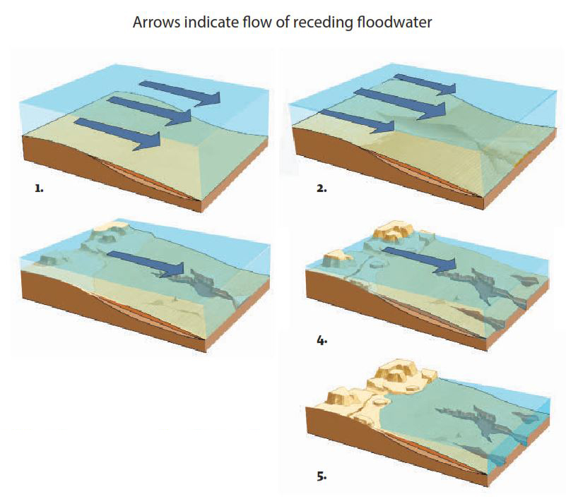
Fig. 4. Origin of submarine canyons. 1–2 Receding floodwaters deposit continental margin sediments while flowing in sheets. 3–4 As the water level falls, channelized flow carves submarine canyons. 5 Present situation.
그림 4. 해저 협곡의 기원. 1-2 물러가는 대홍수 물이 면상을 흐르면서 대륙연변 퇴적물을 퇴적시킨다. 3-4 수위가 떨어지면서 채널화된 흐름이 해저 협곡을 깎아낸다. 5 현재 상황.
References and notes(참고문헌과 주석)
1. Walker, T., A Biblical geological model; in: Walsh, R.E. (Ed.), Proceedings of the Third International Conference on Creationism, technical symposium sessions, Creation Science Fellowship, Pittsburgh, PA, pp. 581–592, 1994; biblicalgeology.net.
2. Pickering, K.T. et al., Deep-Marine Environments, Unwin Hyman, London, U.K., pp. 133–159, 1989.
3. Harris, P.T. and Whiteway, T., Global distribution of large submarine canyons: geomorphic differences between active and passive continental margins, Marine Geology 285:69–86, 2011.
4. Mulder, T. et al., Understanding continentocean sediment transfer, EOS, Transactions, American Geophysical Union 85 (27):257, 261–262, 2004.
5. Karl, H.A. et al., Aleutian basin of the Bering Sea: styles of sedimentation and canyon Arrows indicate flow of receding floodwater development; in: Gardner, J.V. et al., (Eds), Geology of the United States’ Seafloor—The View from GLORIA, Cambridge University Press, New York, NY, p. 305–332, 1996.
6. Green, H.G. et al., Physiography of the Monterey Bay National Marine Sanctuary and implications about continental margin development, Marine Geology 181:55–82, 2002.
7. Perkins, S., Hidden canyons: vast seabed chasms carved by riverlike processes, Science News 167:9–11, 2005.
8. Lastras, G. et al., Geomorphology and sedimentary features in the Central Portuguese submarine canyons, Western Iberian margin, Geomorphology 103 (3):310–329, 1 February 2009; quote on p. 311.
9. Mulder, T. and Alexander, J., The physical character of subaqueous sedimentary density flows and their deposits, Sedimentology 48:269–299, 2001.
10. Oard, M.J., Geomorphology provides multiple evidences for the global Flood, Creation 37(1):47–49, 2015.
11. Further information and references related to the series of articles on landforms presented in Creation magazine can be accessed at creation.com/landform-links.
MICHAEL OARD, M.S.
has an M.S. in atmospheric science and is a retired meteorologist from the US National Weather Service. He has authored numerous books and articles on geology, including Exploring Geology with Mr Hibb. He is on the board of Creation Research Society and is widely regarded as an expert on Ice Age creation topics. For more: creation.com/oard.
 병들고 고통 받는 괴물들 - Lita Cosner 글, 이종헌 역
 ‘아프리카로부터’는 패배 직전에 있다 - Peter Line 글, 이종헌 역