
수로화된(channelized) 홍수 유출에 의해 급격하게 깎인
산록완사면/山麓緩斜面(Pediments)
Michael Oard 글, 이종헌 역
출처: creation magazine Vol. 41(2019), No. 1 pp. 52-55
THE UNIFORMITARIAN ‘slow and gradual’ belief has great difficulty accounting for many of the features on the earth’s surface, called landforms. These can, however, be explained by Flood runoff. Landforms can be divided into two main types, those shaped during the runoff of the sheet flow phase of the Flood, and those shaped during its channelized phase.<1> I have pointed out a number of sheet erosion features in this magazine; this article refers to a channelized-phase landform, the pediment.
동일과정설적인 ‘천천히 그리고 점진적이라는’ 신념은 지형(landforms)이라고 불리는 지구 표면의 많은 특징을 설명하는 데 큰 어려움을 겪는다. 그러나 이것은 대홍수 유출로 설명 할 수 있다. 지형은 크게 두 가지 유형으로 나눌 수 있는데, 대홍수의 판상류(sheet flow) 단계의 유출 동안에 형성된 것과, 수로화 단계 동안에 형성된 것이다.<1> 이 잡지에서 여러 가지의 판상침식(sheet erosion) 특성을 언급했으므로, 이 기사에서는 수로화 단계의 지형, 즉 산록완사면(pediment)을 거론하기로 한다.
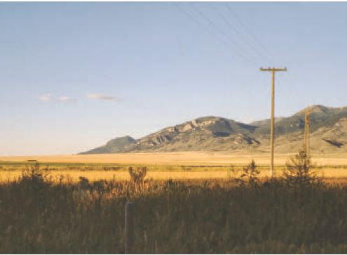
Figure 1. Pediment along the western slope of the Tobacco Root Mountains, southwest Montana, USA. The pediment is about 18 km (11 miles) long parallel to the mountain front, 5 km (3 miles) wide perpendicular to the front, and about 300 m (1,000 feet) higher than the adjacent river.
그림 1. 미국 몬타나 남서부, Tobacco Root 산맥의 서쪽 경사면을 따라 있는 산록완사면. 이 산록완사면의 길이는 산 정면에 평행하게 약 18km(11마일)이며, 폭은 정면에 수직으로 5km(3마일)이고, 인접한 강보다 약 300m(1,000피트) 더 높다.
What is a pediment?(산록완사면/山麓緩斜面이란 무엇인가?)
A pediment is a flat erosion surface that slopes very gently away from a mountain front down toward the middle of the valley. They can form over relatively large areas, occasionally exceeding 300 km² (120 sq. miles) in area. It’s essentially a planation surface (= a large-scale surface planed flat by water) at the foot of a mountain, mountain range, ridge, or plateau (figure 1). Most pediments are found in valleys that were rapidly carved during the channelized phase of the Flood.<2>
산록완사면이란 산의 정면에서 계곡 중앙을 향하여 매우 완만하게 기울어진 편평한 침식 표면을 말한다. 그것은 비교적 넓은 지역에 형성 될 수 있으며 때로는 면적이 300 평방 킬로미터(120 평방 마일)를 초과 할 수도 있다. 그것은 본질적으로 산, 산맥, 산등성이, 또는 고원 (그림 1)의 기슭에 평탄화된 면(= 물에 의해 평평하게 된 대규모 표면)이다. 대부분의 산록완사면은 대홍수의 수로화 단계 동안에 빠르게 깎인 계곡에서 발견된다.<2>
Pediments are common over much of the earth. Although occasionally found in wet-climate areas, they are mostly seen in dry-climate regions. These experience less erosion so the pediments are more likely to keep their original shape. Some valleys display multiple levels of pediments and pediment remnants.
산록완사면은 지구의 대부분에서 공통적으로 발견된다. 습한 기후 지역에서는 이따금씩 발견되지만, 건조 기후 지역에서는 대부분 볼 수 있다. 건조기후 지역은 침식이 적기 때문에 산록완사면이 원래 모양을 유지할 가능성이 더 크다. 일부 계곡은 산록완사면과 그 잔존물이 여러 층으로 보이기도 한다.
Pediments are sometimes eroded in rock that is like that found in the adjacent mountains,<3> while in other areas the erosion has been restricted to the thick layers of sedimentary rock that fill the valley. Some of the early geologists thought pediments were alluvial fans, since they look similar.<4> However, they were greatly surprised to discover not the unconsolidated alluvial sand, gravel and other particles they expected, but hard rock surfaces below a thin veneer of mostly rounded rocks.<5> So, the pediment is a surface left after the erosion of hard rock. And the thin capping of rounded rocks provides a necessary clue to the cause of this widespread erosion. Sometimes there is no such ‘protective’ veneer at all, yet present-day erosion has not thus far destroyed the pediment, indicating the erosion event for the pediment was recent.
산록완사면은 때로는 인접한 산에서 발견되는 것과 같은 암석에서 침식되어 있기도 하지만, 다른 지역에서는 침식이 계곡을 채우는 두꺼운 퇴적암 층으로 제한되어있다. 초기 지질학자 중 일부는 산록완사면이 충적세의 선상지와 비슷하기 생겼기 때문에 그것이라고 생각했었다.<4> 그러나 그들은 그들이 예상했던 굳지 않은 충적세의 모래와 자갈 및 기타 입자를 발견하지 못하고, 대신에 대부분 둥근 암석의 얇은 박판 아래에서 단단한 암석 표면을 발견하고 나서 크게 놀랐다.<5> 따라서, 산록완사면이란 단단한 암석의 침식 이후에 남겨진 표면이다. 그리고 둥근 암석의 얇은 표토는 이 광범위한 침식의 원인에 대해 필요한 단서를 제공한다. 때로는 그러한 ‘보호용’ 박판이 전혀없는 경우도 있지만, 오늘날의 침식이 산록완사면을 아직 파괴하지 않았다는 것은 산록완사면에 대한 침식 현상이 최근의 일임을 나타낸다.
Pediments remarkably flat(산록완사면이 현저히 평평하다)
Pediments are often remarkably flat across the broad scale.<6> The size, flatness, and abundance of these surfaces give further indication as to how they were formed. On a finer scale, channels and rills<7> leading from the mountains often cut into the surfaces across a pediment (figure 2). In fact, most pediments are dissected (cut) by drainage channels that run away from the mountains, but the original planation surface can still be recognized by mentally filling in the channels and reconnecting the remaining undissected surfaces. Prominent geomorphologist Dohrenwend writes:
산록완사면은 종종 광범위한 규모에 걸쳐 현저하게 평평하다.<6> 이 표면의 크기, 평탄도 및 풍부함은 그들이 어떻게 형성되었는지에 대한 더 많은 정보를 제공한다. 더 세밀한 규모에서, 산에서 이어지는 수로와 시내는 종종 산록완사면을 가로 지르는 표면으로 절단한다(그림 2). 사실상, 대부분의 산록완사면은 산에서 멀리 떨어지는 배수로에 의해 절단되지만, 마음속으로 수로를 채워 넣고 절단되지 않고 남아있는 표면을 다시 연결하면 원래는 평탄했던 표면이었음을 여전히 알아볼 수 있다. 저명한 지형학자인 Dohrenwend는 다음과 같이 썼다:
Certainly one of the most remarkable physical attributes of any pediment is the generally planar and featureless character of most (or at least part of) its surface … . Although many large pediments are generally smooth and regular with less than a few metres of local relief, a more complex morphology occurs where shallow drainageways locally incise the pediment surface into irregular patchworks of dissected and undissected topography.<8>
확실히 모든 산록완사면의 가장 주목할 만한 물리적 특성 중 하나는 표면의 대부분 (또는 적어도 일부)이 일반적으로 평평하고 굴곡이 없다는(featureless) 것이다. 많은 대형 산록완사면은 일반적으로 국부적인 기복이 수 미터 이하로 매끄럽고 규칙적이지만, 얕은 배수로가 국소적으로 산록완사면 표면을 절개하여 절개된 지형과 절개되지 않은 지형이 불규칙하게 뒤섞일 때는(patchworks) 보다 더 복잡한 형태의 지형이 발생한다.<8>
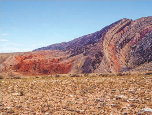
Figure 2. A dissected pediment on near-vertical strata at Sheep Mountain water gap, Wyoming, USA.
그림 2. 미국 와이오밍 Sheep Mountain의 water gap(수극/水隙/강물에 의해 생긴 협곡 또는 협로)에 거의 수직인 지층에 절개된 산록완사면.
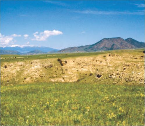
Figure 3. Pediment in the Ruby River Valley along the western slope of the Gravely Range of southwest Montana. Note that the sedimentary beds, that fill the valley, dip to the right (east), while the pediment surface dips to the left (west) and shears the sedimentary layers evenly at a low angle.
그림 3. 몬타나 남서부의 Gravely Range의 서쪽 경사를 따라 Ruby River Valley에 있는 산록완사면. 계곡을 채우고 있는 퇴적층은 오른쪽(동쪽)으로 기울어져 있는 반면, 산록완사면의 표면은 왼쪽(서쪽)으로 기울어져서 퇴적층을 낮은 각도로 평탄하게 절단하고 있음을 주목하라.
Pediments capped by a thin layer of rounded rocks(둥근 바위의 얇은 층으로 덮인 산록완사면)
The rocks capping a pediment are sometimes up to boulder size<9> and are generally rounded. Rocks are rounded by water action, so they give clear indication that water was involved in depositing the thin cap and shaping the pediment. Gravel carried by the current would act as sandpaper, eroding and smoothing the rough surface and rounding the rocks. The gravel formed the pediment, in much the same way as a planation surface.<10> Figure 3 shows a pediment at the edge of the Ruby River Valley in southwest Montana. Notice that the pediment cuts against the dip<11> of the sedimentary rocks at a low angle.
산록완사면을 덮고 있는 암석은 때로는 표석 크기만 하며<9> 일반적으로 둥글다. 암석은 물의 작용에 의해 둥글게 되었기 때문에, 그것은 얇은 뚜껑을 덮고 산록완사면을 형성하는 데 물이 관련되어 있음을 명확하게 나타낸다. 조류에 의해 운반된 자갈은 사포처럼 작용하여 거친 표면을 깎고 부드럽게 하여 암석을 둥글게 만들었다. 자갈은 평탄화 된 표면과 거의 같은 방법으로 산록완사면을 형성했다.<10> 그림 3은 몬타나 남서부의 Ruby River Valley 가장자리에 있는 산록완사면을 보여준다. 산록완사면은 퇴적암의 경사와 반대방향으로 낮은 각도로 절단하고 있음을 주목하라.
Erosion today is on a much smaller scale, usually no more significant than reshaping a river bank or dissecting an existing surface. The sheer size of these pediments indicates a much larger watery event than has ever been observed in history, other than the Deluge. That is why pediments are not seen forming today; they were carved by some past process involving huge amounts of water.
오늘날의 침식은 훨씬 작은 규모로 일어나며, 통상적으로 강둑을 재구성하거나 기존 표면을 절개하는 것 이상으로 중요하지는 않다. 이들 산록완사면의 엄청난 크기는 대홍수 이외에는 역사적으로 관찰되는 그 어떤 것보다 훨씬 더 큰 물과 관련된 사건을 나타낸다. 그것이 오늘날에는 산록완사면이 형성되지 않는 이유이다; 그것은 거대한 양의 물을 포함하는 과거의 과정에 의해 깎인 것이다.
Uniformitarian conundrums(동일과정설의 수수께끼)
Uniformitarian scientists, who do not accept the biblical Flood, have attempted to explain the origin of pediments for more than 100 years and have failed, largely because pediments are not forming today. Instead we observe them being dissected and destroyed.<12, 13, 14> Where pediments exist today, water running across them either incises them or deposits debris on their surfaces.<15> Therefore, running water is not presently forming pediments. C.H. Crickmay commented:
성경의 대홍수를 받아들이지 않는 동일과정설 과학자들은 산록완사면의 기원을 100년이 넘게 설명하려고 시도했었는데, 오늘날에는 산록완사면이 형성되지 않는다는 주된 이유 때문에 실패했다. 대신에 우리는 산록완사면이 절개되고 파괴되고 있는 것을 관찰한다.<12, 13, 14> 오늘날 산록완사면이 존재하는 곳에서는 물이 산록완사면을 가로질러 흘러서 물이 산록완사면을 절개하거나 그 표면에 쇄설물을 퇴적시킨다.<15> 그러므로 흐르는 물은 현재 산록완사면을 형성하지 않는다. C.H. Crickmay는 다음과 같이 언급했다:
There is no reason to suppose that any kind of wasting [erosion] ever planes an area to flatness: decrepitation [wearing, breaking down] always roughens; rain-wash, even on ground already flat and smooth, tends to furrow it [emphasis mine].<16>
어떤 종류의 소모[침식]라도 어떤 지역을 편평하게 한다고 가정할 이유가 없다: 염발음(decrepitation)(마모, 파쇄)는 항상 거칠게 한다; 빗물로 인한 씻김은 심지어 이미 납작하고 매끄럽게 되어 있는 지반 위로 흐를지라도 지반에 고랑을 만드는 경향이 있다.<16>
Dohrenwend also states:
Dohrenwend도 이렇게 말한다:
Pediments have long been the subject of geomorphological scrutiny. Unfortunately, the net result of this long history of study is not altogether clear or cogent and has not produced a clear understanding of the processes responsible for pediment development.<17>
산록완사면은 오랜 기간 동안 지형학적 조사의 대상이 되어왔다. 불행히도,이 오랜 역사의 연구 결과는 완전히 명확하지도 않고 설득력이 없으며, 산록완사면의 형성에 대해 신뢰할만한 과정을 명확하게 이해도 도출하지 못했다.<17>
Uniformitarian scientists have three main hypotheses for explaining the origin of pediments. All of them have fatal flaws. Each depends upon water issuing from the surrounding mountains and running across the surface. This is in spite of the fact that some of the rocks capping the pediments did not originate from the surrounding mountains, but originated far upvalley. Figure 4 shows a thin gravel cap of generally rounded rocks on the pediment in figure 3. Most of the rocks on this pediment are quartzite, a hard, metamorphosed sandstone. The nearest source for these quartzite rocks is over 160 km (100 miles) away. A logical explanation for the origin of pediments would be erosion by strong water currents covering a wide area and flowing parallel to the valley sides.
동일과정설 과학자들이 산록완사면의 기원을 설명하는 데에는 세 가지의 주요 가설을 가지고 있다. 그것들 모두 치명적인 결함이 있다. 각각의 가설은 주변의 산에서 물이 흘러 나와 표면을 가로 지른다고 가정한다. 그들은 산록완사면을 덮고 있는 바위의 일부가 주변의 산에서 온 것이 아니라 먼 계곡 상부(upvalley)에서 왔다는 사실에도 불구하고 그런 가정을 둔다. 그림 4는 그림 3에 있는 산록완사면 위에 일반적으로 둥근 암석을 덮고 있는 얇은 자갈을 보여준다. 이 산록완사면 위에 있는 대부분의 암석은 규암으로써 단단하고 변성된 사암이다. 이 규암의 가장 가까운 근원은 160km(100 마일) 이상 떨어져 있다. 산록완사면의 기원에 대한 논리적인 설명은 넓은 면적을 덮고 골짜기 면에 평행하게 흐르는 강한 물의 흐름에 의한 침식일 것이다.
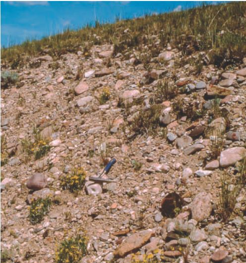
Figure 4. Coarse gravel veneer capping the pediment shown in figure 2. Note that the rocks are generally rounded, and most of them are light-colored quartzites that do not come from the surrounding mountains.
그림 4. 그림 2에 보인 산록완사면을 덮고 있는 굵은 자갈의 박판. 암석들은 일반적으로 둥글고, 그들 대부분은 옅은 색깔의 규암으로써 주변의 산에서 온 것이 아님을 주목하라.
Pediments from late-Flood runoff(대홍수 말기의 유출로 생긴 산록완사면)
Pediments were carved very late in Noah’s Flood when deep floodwater was flowing down valleys on its way to the oceans. The thin capping of rounded rock was deposited as the water drained and gradually lost its momentum. The multiple pediments and pediment remnants that are seen in some valleys can be explained by pulses of valley erosion late in the runoff. They further eroded some pediments leaving a few remnants and sometimes overlaying new pediments. Figure 5 is a schematic on how pediments formed rapidly by fast eroding flows along the valley late in the Flood. Pediments are just one more example of how, despite what critics allege, evidence for the Genesis Flood is especially clear in the area of geomorphology.
산록완사면은 노아의 대홍수 거의 말기에 깊은 홍수 물이 계곡 아래로 흘러 바다로 들어갈 때 깎였다. 둥근 암석의 얇은 덮개는 물이 빠져 나가면서 점차 기세를 잃어 갈 때 퇴적되었다. 일부 골짜기에서 볼 수 있는 다중의 산록완사면과 산록완사면 잔해는 유출 후반의 계곡 침식의 약동(pulse)으로 설명할 수 있다. 그들은 일부 산록완사면을 추가로 침식하면서 약간의 잔해를 남기고 때로는 새로운 산록완사면을 포개었다. 그림 5는 대홍수 말기에 골짜기를 따라 빠른 침식 흐름에 의해 산록완사면이 빠르게 형성되는 것을 보여주는 개략도이다. 산록완사면은 비평가들의 주장에도 불구하고 창세기 대홍수에 대한 증거가 지형학 분야에서 특히 분명하다는 것을 보여주는 또 하나의 예이다.
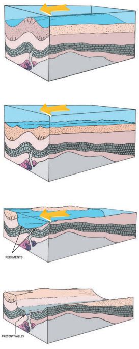
Figure 5. Schematic diagram showing how pediments develop alongside mountains as the Flood water drains downvalley (drawn by Peter Klevberg).
그림 5. 대홍수의 물이 아래 계곡으로 빠져나갈 때 산록완사면이 산과 나란히 발달하는 것을 보여주는 개략도(Peter Klevberg 그림).
References and notes(참고문헌 및 주석)
1. Walker, T., A biblical geologic model; in: Walsh, R.E. (Ed.), Proc. 3rd International Conference on Creationism, technical symposium sessions, Creation Science Fellowship, Pittsburgh, PA, pp. 581–592, 1994; biblicalgeology.net.
2. Oard, M.J., How valleys and canyons formed during Noah’s Flood, Creation 40(2):48–51, 2018.
3. Ritter, D.F., Pediments; in: Process Geomorphology, Wm. C. Brown, Dubuque, IA, pp. 290–299, 1978.
4. Twidale, C.R. and Bourne, J.A., Origin and age of bornhardts, southwest Western Australia, Australian J. Earth Sciences 45:903–914, 1998.
5. Rich, J.L., Origin and evolution of rock fans and pediments, GSA Bulletin 46:999–1,024, 1935.
6. Howard, A.D., Pediment passes and the pediment problem (Part I), J. Geomorphology 5(1):3–31, 1942.
7. A term generally reserved for smaller channels cut by a watercourse.
8. Dohrenwend, J.C., Pediments in arid environments; in: Abrahams, A.D. and Parsons A.J. (Eds.), Geomorphology of Desert Environments, Chapman & Hall, London, U.K., pp. 324, 329, 1994.
9. Technically, rocks whose diameter is > 256 mm (10 in). See Wentworth, C.K., A scale of grade and class terms for clastic sediments, J. of Geology 30(5):377–392, 1922.
10. Crickmay, C.H., The hypothesis of unequal activity; in: Melhorn, W.N. and Flemel, R.C. (Eds.), Theories of Landform Development, George Allen and Unwin, London, U.K., p. 107, 1975.
11. The angle at which they are inclined to the horizontal.
12. Higgins, C.G., Theories of landscape development: a perspective; in: Melhorn, W.N. and Flemal R.C. (Eds.), Theories of Landform Development, George Allen and Unwin, London, U.K., pp. 1–28, 1975.
13. Twidale, C.R., On the origin of pediments in different structural settings, American J. Science 278:1,142–1,176, 1978.
14. Dohrenwend, J.C., Wells, S.J., McFadden, L.D., and Turrin, B.D.; In, Gardiner, V. (Ed.), International Geomorphology 1986, Proceedings of the 1st International Conference on Geomorphology, Part II, pp. 1,047–1,062, 1987.
15. Garner, H.F., The Origin of Landscapes: A Synthesis of Geomorphology, Oxford University Press, New York, NY, pp. 343–344, 1974.
16. Crickmay, C.H., The Work of the River: A Critical Study of the Central Aspects of Geomorphology, American Elsevier Publishing Co., New York, NY., p. 127, 1974.
17. Dohrenwend, ref. 8, p. 321.
MICHAEL OARD
has an M.S. in atmospheric science and is a retired meteorologist from the US National Weather Service. He has authored numerous books and articles, including Exploring Geology with Mr Hibb. He is on the board of Creation Research Society and is widely regarded as an expert on Ice Age creation topics. For more: creation.com/oard.
 에덴은 어디에 있었나? - Lita Cosner and Robert Carter 글, 이...
 공룡 알은 전지구적 창세기 대홍수를 가리킨다-Michael Oard 글, ...