후기 홍수유출 동안 수극과 풍극이 깎았다
Michael Oaed 글, 이종헌 역
출처: creation magazine Vol. 41(2019), No. 2 pp. 48-51
Water and wind gaps, two amazing landforms on the earth’s surface, cut through mountains and ridges.(1) They are exciting evidence for the global Flood.(2,3) According to the Glossary of Geology, a water gap is defined as: “A deep pass in a mountain ridge, through which a stream flows; esp. a narrow gorge or ravine cut through resistant rocks by an antecedent or superposed stream.”(4) In other words, a water gap is a perpendicular cut through a mountain range, ridge, or other rock barrier. It is a gorge that a river or stream flows through. It is highly unlikely these gorges were cut by the river that now runs through. Wind gaps are like water gaps but are not deep enough for water to flow through. Only wind passes through, which is why they are called wind gaps.
지표면에 있는 두 개의 놀라운 지형인 수극과 풍극이 산과 능선을 깎아낸다.(1) 그것은 전지구적 대홍수에 대한 흥미로운 증거이다.(2,3) 지질학 용어집에 따르면 수극의 정의는 다음과 같다: “산등성이에 깊숙한 수로가 생겨 거기로 강이 흐른다; 특히 선행의 흐름 혹은 중첩된 흐름에 의해 좁은 계곡이나 협곡이 저항하는 암석을 깎는다.”(4) 다시 말하면, 수극이란 산등성이, 능선 또는 다른 암벽을 가로 지르는 직교 절단이다. 그것은 강이나 시내가 통과하여 흐르는 협곡이다. 이 협곡이 현재 흐르는 강에 의해 깎이는 가능성은 거의 없다. 풍극은 수극과 비슷하지만 그것을 통과하여 물이 흐를 정도로 깊지는 않다. 오직 바람만 통과하기 때문에 그것을 풍극이라고 부른다.
‘Loaded’ geological definitions(‘함축하는 바가 있는’ 지질학적 정의)
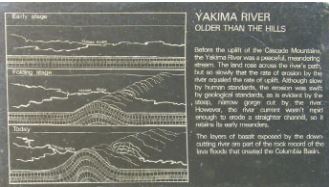
Geological definitions are supposed to be descriptive, but the above definition of a water gap contains two hypotheses that assume their origin: an antecedent and a superposed stream. The first hypothesis involves an ‘antecedent stream’, which is defined as a stream that was established before uplift of the mountain or ridge, and which maintained its original course in spite of the uplift. It did this by incising its channel at approximately the same rate as the land was rising.(5) The idea is that the stream existed prior to, or antecedent to, the present topography. Figure 1 shows an interpretive sign in front of a water gap on the Yakima River south of Ellensburg, Washington, USA explaining how a supposed antecedent Yakima River created the gap. The Yakima River is imagined to have come first and then the ridge slowly uplifted while the river continued to flow through and erode the ridge at the same location. This is an unlikely geological coincidence.
지질학적 정의는 서술적일 것으로 생각되지만, 위의 수극에 대한 정의는 그 기원을 가정하는 두 가지 가설을 포함한다: 즉, 선행의 흐름과 중첩된 흐름. 첫 번째 가설은 ‘선행의 흐름’을 포함하는데, 그것은 산이나 능선이 융기되기 이전에 형성된 흐름으로 정의되며, 융기에도 불구하고 원래의 흐름 경로가 그대로 유지되는 것이다. 그것은 땅이 상승하는 것과 거의 같은 속도로 수로가 절개됨으로써 가능하다.(5) 그 개념은 흐름이 현재의 지형 이전에 존재했거나 바로 앞서서 존재했다는 것이다. 그림 1은 미국 워싱턴의 엘렌스버그(Ellensburg) 남쪽에 있는 야키마강(Yakima River)의 수극(water gap) 앞에 있는 해설 표지판으로써, 선행하던 야키마강(Yakima River)이 어떻게 수극을 만들었는지를 설명하고 있다. 야키마 강이 먼저 있었다고 생각되며, 다음으로 능선이 서서히 융기하는 동안 강이 계속 흐르면서 같은 위치에서 능선을 통과하며 침식시켰다. 이것은 있을 법하지 않은 지질학적 우연이다.
|
야키마강이 언덕보다 오래되었다. Cascade 산맥이 융기하기 이전에 야키마강은 평화스럽게 굽이쳐 흐르는 흐름이었다. 땅은 강의 경로를 가로질러 솟아올랐지만, 너무나 느려서 강에 의한 침식 속도가 융기하는 속도와 같았다. 인간적인 기준으로는 느리지만 지질학적 표준으로 본다면 강이 깎아낸 가파르고 좁은 협곡이 증거하듯이 그 침식은 빨랐다. 그러나 강의 조류가 직선의 수로를 침식할 정도로 급하지는 않아서 초기의 굽이쳐 흐르는 상태를 유지한다. 아래로 깎는 강에 의해 드러난 현무암층은 컬럼비아 유역을 형성한 용암유출이 만들어낸 암석의 일부이다. |
Figure 1. Interpretive sign explaining the antecedent river hypothesis for the Yakima River cutting through a lava ridge. The Yakima River supposedly came first and then the ridge slowly uplifted while the river continued to erode through the ridge at the same location.
그림 1. 용암 능선을 통과하여 깎은 야키마강에 대한 선행하는 강 가설을 설명하는 해설 표지판. 짐작컨대 야키마강이 먼저 있었고 다음에 능선이 천천히 융기하는 동안 같은 위치에서 강이 지속적으로 능선을 통과하며 침식했다.
The other idea, a superposed stream, involves “A stream that was established on a new surface and that maintained its course despite different lithologies [rock types] and structures encountered as it eroded downward into the underlying rocks.”(6) Figure 2 shows a schematic of the supposed origin of a water gap by a superposed stream. The assumption in this mechanism is that erosion by a stream cut hundreds of metres of thickness of rock from the landscape over a wide area over millions of years. Supposedly neither time nor geology deflected the stream. How likely is such an idea?
또 다른 개념인 중첩된 흐름은 “새로운 표면에 형성되어, 암석의 종류가 다르고 기초에 있는 암석으로 아래로 침식될 때 발생하는 구조임에도 불구하고 그 진로를 유지하는 흐름”을 포함한다.(6) 그림 2는 중첩된 흐름에 의한 수극의 가상적 기원에 대한 개략도를 나타낸다. 이 메커니즘의 가정은 흐름에 의한 침식이 수백만 년에 걸쳐 넓은 면적의 지형에서 수백 미터의 두께로 암석을 잘라낸다는 것이다. 시간도 지질도 흐름을 비켜가게 하지 않았다고 가정한다. 그런 개념이 어떻게 가능할까?

Figure 2. Block diagram of the superimposed stream hypothesis. The stream supposedly maintains its course as most of the top layer of sedimentary rock is removed at exactly the same rate by erosion.(drawn by Bryan Miller).
그림 2. 중첩된 흐름 가설의 블록 다이어그램. 이 흐름은 퇴적암의 최상층의 대부분이 침식에 의해 정확히 같은 속도로 제거됨에 따라 그 수로를 유지한다고 추측한다(Bryan Miller 그림).
Ironically, the above two mechanisms, while they remain in the definition of a water gap, have been mostly rejected by long-age geologists. Geologists more prefer a third mechanism, ‘stream capture’ (figure 3). In this idea, erosion begins with two streams flowing parallel to each other, separated by a ridge. Over millions of years, according to this hypothesis, the tributary of one stream erodes through the ridge between the streams and captures the water of the other stream.
아이러니하게도, 위의 두 메커니즘은 수극에 대한 정의로 남아있지만, 오랜 연대 지질학자들에 의해 대부분 거부되었다. 지질학자들은 세 번째 메커니즘인 ‘흐름 포획’을 선호한다(그림 3). 이 개념에서, 침식은 서로 평행하게 흐르는 두 개의 흐름으로 시작하며 하나의 능선에 의해 분리된다. 이 가설에 따르면, 수백만 년에 걸쳐 하나의 흐름의 지류가 그 흐름들 사이의 능선을 침식하고 다른 흐름의 물을 포획한다.
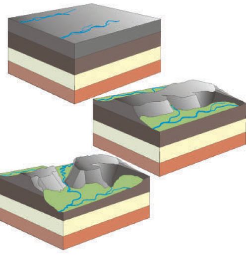
Figure 3. Block diagram of the stream-capture hypothesis.(drawn by Peter Klevberg)
그림 3. 흐름 포획 가설에 대한 블록 다이어그램(Peter Klevberg 그림)
These three mechanisms show that uniformitarian scientists always have at least one idea for the origin of particular landforms. The question is whether they have any evidence for any of them.
이들 세 가지 메커니즘은 동일과정설 과학자들이 항상 특정 지형의 기원에 대해 적어도 하나의 개념을 가지고 있음을 보여준다. 문제는 그들 중 어떤 것이라도 어떤 증거를 가지고 있는지의 여부이다.
Amazing water gaps(놀라운 수극)
There are thousands of water gaps across the earth, where a river or stream appears to have cut through a barrier when it should have gone around. The Appalachian Mountains alone, in eastern
North America, have around 1,700 water gaps that flow through barrier ridges.
지구 곳곳에는 수천 개의 수극이 있다. 강이나 흐름이 장벽을 둘러서 가야할 것으로 보이는 곳에서 그것을 통과하여 절단한 것으로 보인다. 아메리카 북동부에 있는 애팔래치아 산맥 하나에만도 능선 장벽을 통과하여 흐르는 수극이 약 1,700 개 정도 있다.
The Shoshone River water gap in Wyoming, central USA, passes through the Rattlesnake Mountains just west of Cody. The gap is a gorge 760 metres (2,500 feet) deep. On the other side of the mountains is a low area around the southern edge of the Rattlesnake Mountains. When the sediments were higher in the valley, the river should have easily gone around the mountains. Instead the river passes through a deep gorge through the edge of the mountains. It is as if the river ran uphill and then downhill to carve the canyon. This is a big problem for the idea that the river carved the gap since rivers follow the law of gravity and run downhill.
미국 중부 와이오밍 주에 있는 쇼쇼니강(Shoshone River)은 코디(Cody)의 정서쪽에 있는 Rattlesnake 산맥을 통과하여 지나간다. 그 틈(gap)은 760미터(2,500피트) 깊이의 협곡이다. 산의 반대쪽에는 Rattlesnake 산맥의 남쪽 가장자리 주변의 낮은 지역이 있다. 계곡에서 퇴적물이 더 높아질 때, 강은 산 주변을 쉽게 돌아가야 했다. 그런데 대신에 강은 깊은 계곡을 지나 산의 가장자리를 통과하여 지나간다. 그것은 마치 강이 오르막을 갔다가 내리막으로 달려 협곡을 깍은 것처럼 보인다. 이것은 강이 중력의 법칙을 따르고 내리막으로만 달리기 때문에 강이 틈새를 깍았다는 개념에는 큰 문제가 있다.
Other notable water gaps in the western United States include Hells Canyon, in which the Snake River runs through the Wallowa Mountains in northeast Oregon and the Seven Devils Mountains in Idaho.(7) On the Idaho side, the walls of Hells Canyon reach a height of 2,440 metres (8,000 feet), making it the deepest canyon in North America, even deeper than Grand Canyon. Hells Canyon is about 145 kilometres (90 miles) long, about ⅓ the length of Grand Canyon.
미국 서부의 또 다른 주목할 만한 수극으로 헬스 캐년(Hells Canyon)이 있는데, 거기서는 Snake강이 오레곤 북동쪽의 Wallowa 산맥과 아이다호의 Seven Devils 산맥을 통과하여 지나간다.(7) 아이다호 측에서는 Hells 캐년 벽의 높이가 2,440미터(8,000 피트)에 이르는데 이는 북아메리카에서 가장 깊은 협곡이고 그랜드 캐년보다 더 깊다. Hells 캐년은 길이가 약 145km(90마일)로 그랜드 캐년 길이의 약 1/3이다.
Another significant water gap is associated with the Green River that flows through southwest Wyoming to the Uinta Mountains, an east-west range in northeast Utah. The range has almost a dozen peaks that exceed 4,000 metres (13,000 feet). On the north side of the Uinta Mountains, the Green River first flows east, parallel to the mountains, before turning south through hard quartzite in the core of the Uinta Mountains.(8) This water gap is named Lodore Canyon or Gates of Ladore (figure 4). It is a narrow slot canyon 700 metres (2,300 feet) deep. The river could easily have gone around the mountains at a much lower elevation just 3 kilometres (2 miles) east of the gap.(9) To add to the puzzle for uniformitarian science is the belief that the water gap is comparatively young geologically, only about 5 million years old within their dating scheme.(10)
또 다른 중요한 수극은 남서부 와이오밍을 통과하여 유타 북동부의 동서를 잇는 Uinta 산맥으로 흐르는 Green 강과 관련이 있다. 그 구역 안에는 4,000미터(13,000 피트)를 넘는 봉우리가 거의 12 개가 있다. Uinta 산맥의 북쪽에서 Green 강은 먼저 산맥과 평행하게 동쪽으로 흐르고, Uinta 산맥의 핵심에 있는 단단한 규암을 통과하여 남쪽으로 돌아 흐른다.(8) 이 수극은 Lodoro 캐년 혹은 Ladore의 문이라는 이름이 붙어있다.(그림 4). 그것은 깊이가 700미터(2,300 피트)인 좁은 틈새의 캐년이다. 이 수극에서 동쪽으로 3킬로미터(2마일)밖에 떨어지지 않은 훨씬 낮은 고도에서 이 강은 쉽게 산을 돌아갈 수 있었다.(9) 동일과정설 과학에 대해 수수께끼를 덧붙이는 것은 이 수극이 그들의 연대 체계로 약 5백만년밖에 안되는, 지질학적으로 비교적 젊다는 믿음이다.(10)
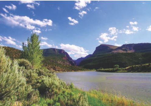
Figure 4. Ladore Canyon on the Green River entering the eastern Uinta Mountains in a slot canyon 700 metres (2,300 feet) deep.
그림 4. 700미터(2,300피트) 깊이의 틈새 협곡에 있는 동부 Uinta 산맥으로 들어가는 Green 강의 Ladore 캐년.
The Grand Canyon is yet another famous water gap that is around 1,600 metres (5,200 feet) deep. It also avoids the logical path and passes through several high(11) plateaus instead of going around them.
그랜드 캐년은 약 1,600미터(5,200피트) 깊이의 또 다른 유명한 수극이다. 그것 또한 여러 개의 높은(11) 고원 주위로 돌아가는 대신에 논리적 경로를 피하여 그것들을 통과하여 지나간다.
The deepest water gaps in the world are in the Himalaya Mountains. Eleven rivers start on the southern Tibetan Plateau, which is a huge planation surface traversed by deep narrow gorges. These rivers pass through the Himalayas through water gaps, whereas they could have more easily snaked around the uplifts to empty into the Indian Ocean.(12,13) A few of these water gaps are 6 kilometres (4 miles) deep!
세계에서 가장 깊은 수극은 히말라야 산맥에 있다. 11개의 강이 티베트 고원 남쪽에서 시작한다.이 고원은 깊고 좁은 협곡이 통과하는 거대한 평탄면이다. 이 강들은 수극을 통해 히말라야 산맥을 통과해 흐르는데, 그렇지 않았다면 융기된 곳 주위를 뱀처럼 돌아 인도양으로 흘러들어갔을 것이다.(12,13) 이러한 수극의 일부는 깊이가 6킬로미터(4마일)이다!
Wind gaps(풍극)
A wind gap is: “A shallow notch in the crest or the upper part of a mountain ridge. Usually, it is at a higher level than a water gap.”(14) To qualify as a wind gap, the notch has to be an erosional notch and not caused by faulting or some other mechanism. In other words, the top of the entire ridge, at one time, was level and at about the same altitude, until a notch was eroded into the ridge across its top. Figure 5 shows the famous Cumberland wind gap between Virginia and Kentucky, USA. The early pioneers frequently used this gap when traveling west through the Appalachian Mountains. A wind gap is considered an ancient water gap, but which was later left high and dry.
풍극이란: “산 능선의 꼭대기 또는 윗부분에 있는 얕은 산골짜기(notch)이다. 일반적으로 그것은 수극보다 높은 위치에 있다.”(14) 풍극의 자격을 갖추려면 산골짜기가 침식으로 인한 산골짜기가 되어야 하며, 단층작용이나 다른 메커니즘에 의한 것이 아니어야 한다. 다른 말로하면, 한때는 전체 능선의 꼭대기가 같은 높이이거나 거의 같은 고도이었다가 그 정상을 가로질러 능선 안으로 산골짜기가 침식되어야 한다. 그림 5는 미국 버지니아와 켄터키 사이에 있는 유명한 Cumberland 풍극을 보여준다. 초기 개척자들이 애팔래치아 산맥을 통과하여 서쪽으로 여행 할 때 이 풍극을 자주 이용했다. 풍극은 고대에는 수극이었던 것이 나중에 높고 건조한 상태로 남아 있는 것으로 여겨진다.
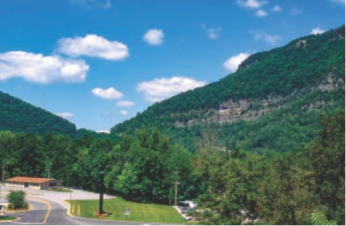
Figure 5. The Cumberland wind gap, 300 metres (1,000 feet) deep, through the Appalachian Mountains along the Virginia/Kentucky border near Middlesboro, Kentucky (view northwest from Highway 58).
그림 5. 켄터키 주 Middlesboro 근처의 버지니아/켄터키 주 경계를 따라 애팔래치아 산맥을 통과하는, 300미터(1,000피트) 깊이의 Cumberland 풍극(하이웨이 58에서 북서쪽으로 보기).
Major mysteries of uniformitarian geology(동일과정설 지질학의 주요 미스테리들)
Despite the above three main ideas and several minor ideas, the origin of water and wind gaps, assuming present processes, remains a mystery. Thomas Oberlander, who has extensively researched water gaps, opines:
위의 세 가지 주요 개념과 몇 가지 사소한 개념에도 불구하고, 현재의 과정을 가정하는 수극과 풍극의 기원은 미스테리를 남긴다. 수극을 광범위하게 연구한 Thomas Oberlander는 다음과 같은 의견을 낸다:
“Large streams transverse to deformational structures [i.e. streams flowing through water gaps] are conspicuous geomorphic elements in orogens [mountain ranges] of all ages. Each such stream and each breached structure presents a geomorphic problem. However, the apparent absence of empirical evidence for the origin of such drainage generally limits comment upon it [emphasis added].”(15)
“변형 가능한 구조물을 가로지르는 대규모 흐름[즉, 수극을 통과하여 흐르는 흐름]은 모든 연대의 조산대(산맥)에 있는 특징적인 지형학적 요소이다. 그러한 각각의 흐름과 각 파열된 구조는 지형 학적 문제를 나타낸다. 그러나 그러한 배수의 기원에 대한 경험적 증거가 명백하게 부재한 것은 일반적으로 그것에 대한 논평을 제한한다.”(15)
Channelized Flood runoff easily carved water and wind gaps
(수로화된 대홍수 유출이 수극과 풍극을 쉽게 깎았다)
Water and wind gaps were formed as the global floodwaters drained off the uplifting continents across the mountains.(16) Figure 6 shows water flowing perpendicular to a transverse ridge, forming shallow notches on the ridge. These notches continue to erode downward as the water accelerates through the notch as the water level drops. After the Flood water is completely drained, rivers take advantage of the newly-formed channel. Wind gaps were formed in the same way but not cut as deeply, and are thus at too high an elevation for water to flow through them now.
수극과 풍극은 전 세계적인 대홍수의 물이 융기하는 대륙에서 산을 가로 질러 빠져 나감으로써 형성되었다.(16) 그림 6은 가로지르는 능선에 직각으로 흐르는 물이 능선에 얕은 산골짜기를 형성하는 것을 보여준다. 이들 산골짜기는 수위가 떨어지면서 산골짜기를 통과하며 물이 가속함에 따라 계속해서 아래로 침식한다. 대홍수 물이 완전히 빠진 이후, 강은 새로 형성된 통로를 이용한다. 풍극은 같은 방식으로 형성되었지만 깊게 깎이지는 않았으며, 따라서 지금은 그것들을 통과하여 물이 흐르기에는 높이가 너무 높다.
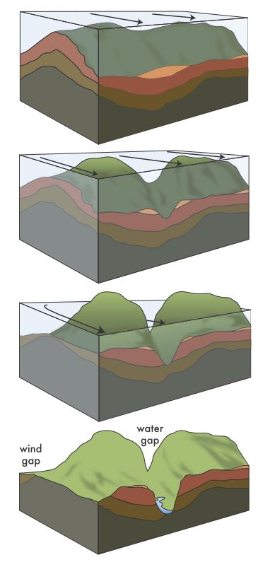
Figure 6. Schematic showing how receding floodwaters formed water and wind gaps.(drawn by Peter Klevberg).
그림 6. 물러가는 대홍수 물이 수극과 풍극을 형성하는 것을 보여주는 모식도(Peter Klevberg 그림).
More examples of water and wind gaps are those carved by the Lake Missoula Flood, a few hundred years after Noah’s Flood. This Ice Age Flood, now known to have carved the spectacular ‘Channeled Scablands’ of the northwestern USA out of solid rock, was probably the second largest flood in Earth history. It took place at the peak of the Ice Age. Despite overwhelming geological evidence for it, it required decades of struggle before eventually becoming accepted as a reality, so strong was the effect of the prejudice in favour of ‘slow and gradual’ mechanisms in geology. The Lake Missoula Flood is known to have carved numerous water and wind gaps through ridges.(17,18) The evidence it left behind thus shows clearly how monstrous floods easily carve water and wind gaps.
수극과 풍극에 대한 더 많은 사례는 노아의 홍수 이후 수백 년이 지나서 Missoula 호수 대홍수에 의해 깎인 것들이다. 견고한 암석으로부터 미국 북서부의 장엄한 ‘수로가 나 있는 환산용안지대’를 깎은 것으로 알려진 이 빙하기 대홍수는 아마도 지구 역사상 두 번째로 큰 홍수 일 것이다. 그것은 빙하기의 정점에서 일어났다. 그것에 대한 압도적인 지질학적 증거에도 불구하고, 결국 현실로 받아들여지기까지 수십 년의 투쟁이 필요했는데, 지질학에서 ‘느리고 점진적인’ 메커니즘을 선호하는 편견의 영향이 강했기 때문이다. Missoula 호수의 대홍수는 산능선을 통과하여 수많은 수극과 풍극을 깎은 것으로 알려져 있다.(17,18). 따라서 그것이 뒤에 남긴 증거는 괴물과 같은 홍수가 수극과 풍극을 쉽게 깎을 수 있다는 것을 분명하게 보여준다.
References and notes
1. Oard, M.J., Do rivers eroded through mountains? Water gaps are strong evidence for the Genesis Flood, Creation 29(3):18–23, 2007; creation.com/watergaps.
2. Oard, M.J., Flood by Design: Receding Water Shapes the Earth’s Surface, Master Books, Green Forest, AR, 2008.
3. Oard, M.J., (ebook), Earth’s Surface Shaped by Genesis Flood Runoff, 2013; Michael.oards.net/GenesisFloodRunoff.htm.
4. Neuendorf, K.K.E., Mehl, Jr., J.P., and Jackson, J.A., Glossary of Geology, Fifth Edition, American Geological Institute, Alexandria, VA, p. 715, 2005.
5. Neuendorf et al., ref. 4, p. 27.
6. Neuendorf et al., ref. 4, p. 645.
7. Val l ier, T., Islands & Rapids: A Geological Story of Hells Canyon, Confluence Press, Lewiston, ID, 1998.
8. Bradley, W.H., Geomorphology of the North Flank of the Uinta Mountains, U. S. Geological Survey Professional Paper 185—I, Washington, D.C., 1936.
9. Powell, J.L., Grand Canyon: Solving Earth’s Grandest Puzzle, PI Press, New York, NY, p. 8, 2005.
10. Powell, ref. 9, p. 152. This would be very late in Noah’s Flood within the biblical timeframe.
11. Oard, M.J. A Grand Origin for Grand Canyon, Creation Research Society, Chino Valley, AZ, 2014.
12. Lave, J. and Avouac, J.P., Fluvial incision and tectonic uplift across the Himalayas of central Nepal, Journal of Geophysical Research 106(B11):26,561–26,591, 2001.
13. Oberlander, T.M., Origin of drainage transverse to structures in orogens; in: Morisawa, M. and Hack, J.T. (Eds), Tectonic Geomorphology, Allen and Unwin, Boston, MA, pp. 155–182, 1985.
14. Neuendorf et al., ref. 4, p. 723.
15. Oberlander, ref. 13, p. 155.
16. Walker, T., A Biblical geological model; in: Walsh, R.E. (Ed.), Proceedings of the Third International Conference on Creationism, technical symposium sessions, Creation Science Fellowship, Pittsburgh, PA, pp. 581–592, 1994; biblicalgeology.net.
17. Oard, M.J., The Missoula Flood Controversy and the Genesis Flood, Creation Research Society Books, Chino Valley, AZ, 2004.
18. Oard, M.J., The Great Missoula Flood: Modern Day Evidence for the Worldwide Flood, Awesome Science Media, Canby, OR, 2014.
MICHAEL OARD
has an M.S. in atmospheric science and is a retired meteorologist from the US National Weather Service. He has authored numerous books and articles, including Exploring Geology with Mr Hibb. He is on the board of Creation Research Society and is widely regarded as an expert on Ice Age creation topics. For more: creation.com/oard.

 파란 장미 - Gordon Howard 글, 이종헌 역
 자궁으로부터의 놀라운 여행(신생아 순환의 놀라운 변화)